
Dominican weekend weather outlook
DECREASE IN RAINS … HURRICANE ISAIAS VERY DISTANT FROM THE DOMINICAN REPUBLIC
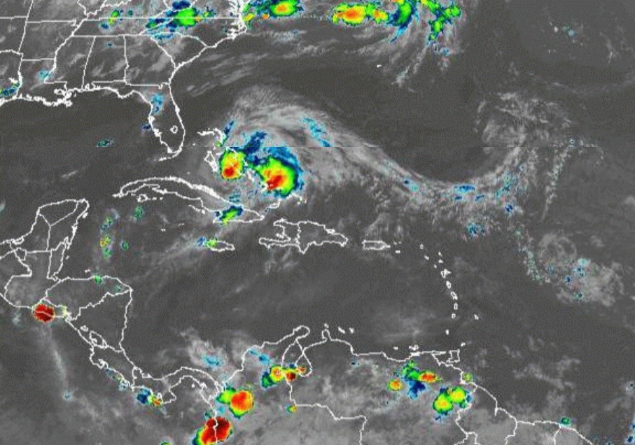
The cloud fields associated with Hurricane Isaías begin to move away from the Dominican territory, which is allowing the entry of an air mass with lower moisture content, limiting rainfall significantly over most of the national geography, however, due to local conditions associated with daytime warming, some showers are not ruled out towards the northeast, northwest and central Cordillera regions especially in the afternoon.
For tomorrow Sunday in the morning hours, good weather conditions will prevail, however, in the afternoon as a result of the approach of a tropical wave, they will be generating cloudy with weak and scattered precipitations towards some provinces of the Northeast, Southeast, and Central Cordillera (Central Range) regions.
Hurricane Isaías was located this morning about 125 km south/southeast of Nassau (Bahamas), its maximum sustained winds are 140 kph. Its hurricane-force winds extend about 55 km from its center and storm winds about 280 km. It is moving northwest at about 19 kph, with this movement expected to continue in the next 24 hours.
ONAMET is reporting another Tropical Depression No.10 located about 430 km to the east of the Cape Verde Islands, has maximum sustained winds of 55 mph, and is moving north at 15 kph. This phenomenon due to its distance and displacement does not represent a danger to the country.
ONAMET is also monitoring an area of heavy showers and thunderstorms that are located about 1,400 kilometers from the arc of the Lesser Antilles with a low chance to develop into a tropical cyclone in the next 48 hours.
ONAMET maintains over several provinces a meteorological ALERT for overflowing rivers, streams and ravines.
Today: Partly cloudy to cloudy with some showers in the afternoon, towards the Northeast, Southeast, and Central Cordillera regions.
Summary: Isaías cloudy remnants are leaving the country … Few showers of rain today.
Sunday: Slight increase in the activity of rain in the afternoon due to the incidence of a tropical wave towards the northeast, southeast, and central Cordillera regions.
Santo Domingo and its municipalities: Partly cloudy with some local showers.
National District: Partly cloudy with some local showers.
Monday: Partly cloudy with scattered showers, thunderstorms in the regions: Northwest, Central Cordillera, and the border area.
Santo Domingo and its municipalities: Partly cloudy at times with showers.
National District: Scattered clouds to partly cloudy.


