
Scattered showers, hot temperatures, and abnormal waves for this Monday
In the afternoon, cloud concentrations will begin accompanied by scattered showers with isolated thunderstorms.
Santo Domingo, DR
This Monday morning, a panorama of atmospheric stability will predominate, causing a sky with scattered clouds to half cloudy at times, indicates the National Meteorological Office (ONAMET).
However, in the afternoon, the cloud concentrations will begin accompanied by scattered showers with isolated thunderstorms, mainly towards the northeast regions’ localities, the Central mountain range, and the border area. In other regions, there will be scattered clouds and a few showers. Hot temperatures will continue.
Onamet maintains the recommendation to the operators of fragile and medium-sized vessels to navigate with caution near the coastal perimeter.
Tuesday, the swells will increase again, so it is recommended to stay in port from Cabo Engaño (La Altagracia) to Luperón (Puerto Plata) due to abnormal swell, being higher offshore.
It is recommended that bathers use the beaches with caution and follow civil defense organizations’ guidelines.
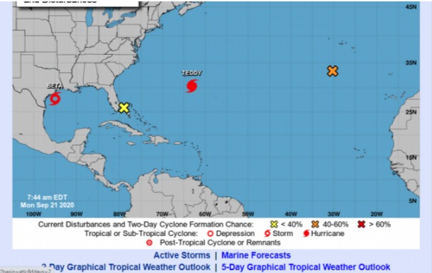
Onamet informs that it monitors the tropical depression Wilfred, which degenerated, leaving only remnants.
It indicates that Hurricane Teddy is located 435 kilometers south/southeast of Bermuda, maximum sustained winds of 165 kph, and moving northwest at about 15 kph. Also, Tropical Storm Beta, located 150 km east/southeast of Galveston, Texas, sustained 85 kph and moved north/northeast at 9 kph.
Also, an area of downpours and thunderstorms is monitored, with a 60% probability of becoming a hurricane in 48 hours. These phenomena do not represent a danger for the Dominican Republic.


