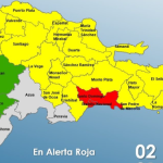
Tropical wave will cause downpours and winds

A tropical storm surge and a tropical wave are expected to cause downpours today, with thunderstorms and wind gusts over the northeast, southeast, including Greater Santo Domingo, southwest, the Cordillera Central, and the border area, according to forecasts from the National Meteorological Office.
Temperatures will continue to be hot in much of the country, with highs ranging from 30 to 33 degrees Celsius (86-91°F).
ONAMET is monitoring the evolution of Hurricane Zeta, which last night was 235 km (146 mi) southwest of the Mississippi River mouth, with maximum sustained winds of 155 km/h (96 mph)and was moving north/northeast at 35 km/h (22 mph). Because of its position and trajectory, it is not yet a danger to the Dominican Republic.
There will be downpours, electrical storms, and gusts of wind in the National District and the province of Santo Domingo.
By tomorrow, Friday, Onamet foresees that a tropical wave over the Dominican Republic will affect the occurrence of moderate to intense downpours with storms and gusts of wind in the northeast, southeast, the Central Mountain Range, and the border area.
Yesterday afternoon, the wind’s dragging and the effects of a moisture trough caused downpours with isolated thunderstorms in some points of the northeast, southeast, and the Cordillera Central.
In the rest of the country, the weather conditions were stable, with scattered clouds and low rainfall.


