Tropical Storm Grace is currently in Caribbean waters
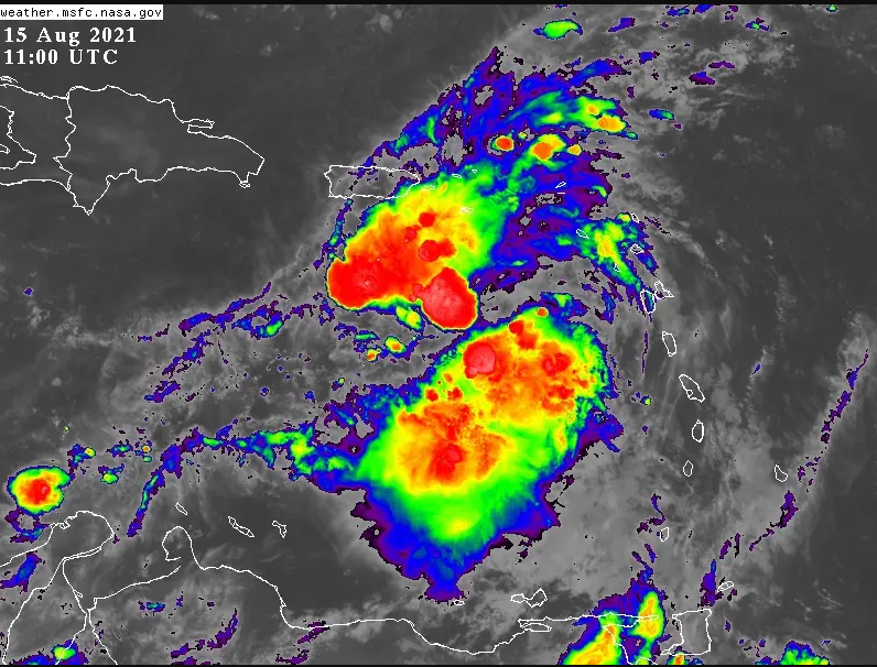
For this Sunday in the morning hours, there will be scattered clouds and sun, and late in the afternoon, we will have cloudy increases accompanied by downpours, thunderstorms, and wind gusts, due to the effects of GRACE on the regions, east, northeast, southeast, the Cordillera Central and the border area. Tropical Cyclone GRACE is located at latitude 16.9 North and longitude 64.4 West, about 440 km southeast of Cape Engaño. We will continue with hot temperatures between 29ºC and 32ºC.
It is forecast that from the early hours of Monday, more significant cloudiness of tropical cyclone CRACE will enter, which will begin to produce quantitative rains, thunderstorms, and wind with storm forces over the regions, east, northeast southeast and will extend to other areas in the day and night covering much of the national territory. On Tuesday, we will begin to notice a gradual improvement in conditions due to the departure of the phenomenon and at night skies of scattered clouds.
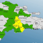
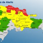
The National Bureau of Meteorology, ONAMET, maintains an ALERT for probable tropical storm conditions from the border with Haiti to Cabo Engaño, and from Cabo Engaño to Cabo Francés Viejo (María Trinidad Sánchez). An ALERT means that within 48 hours or less, one or two of the three effects associated with a tropical cyclone could be felt in areas under alerts, such as heavy rain, storm-intensity winds, and abnormal tides or waves.
Due to the rains that have occurred and are forecasted, ONAMET maintains the levels of Meteorological Alert for possible floods in rivers, streams, streets, ravines, washes, and landslides.