ONAMET monitors hurricane and rainfall zone, tropical wave generates regional rains
Santo Domingo, DR.
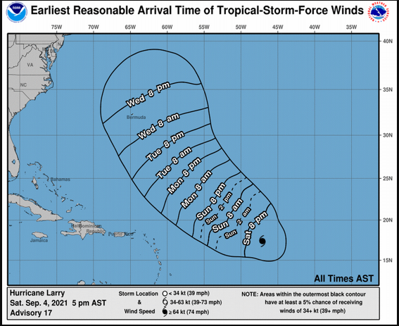
The National Meteorological Office (ONAMET) monitors Hurricane Larry, which is located about 1,700 kilometers east of the Leeward Islands.
It reported that the phenomenon has maximum sustained winds of 205 kilometers per hour and is moving west-northwest at 24 kilometers per hour.
Likewise, an area of showers and disorganized thunderstorms associated with a low-pressure system to the southeast of the Yucatan Peninsula, which has a very low probability of becoming a tropical cyclone in the next 48 hours, will be monitored.
Forecasts
Onamet reported that downpours accompanied by thunderstorms and wind gusts continue in several country regions due to the passage of a tropical wave and a trough at high altitudes.
The office indicated that temperatures would remain warm and maritime conditions are optimal.
An air mass will characterize the prediction for this Sunday’s weather with low humidity values and dust particles coming from the Sahara, limiting rains in most of the country.
“However, we foresee an increase in clouds with local downpours, isolated thunderstorms and possible wind gusts in some parts of the northwest, the Haitises and the Central Cordillera. As for the remaining regions, scattered clouds, grayish skies and high wind chill will prevail,” Onamet detailed.