Tropical depression would hit Dominican soil on Saturday afternoon
It could turn into a tropical storm in the next few hours
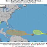
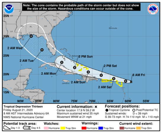
The National Meteorological Office (ONAMET) continues to monitor the evolution and development of tropical depression number 13 of the cyclonic season, located about 490 kilometers (km) east of the Lesser Antilles, with maximum sustained winds of 55 kilometers per hour (km/h). Projections indicate that this system could touch Dominican soil on Saturday afternoon.
The atmospheric phenomenon is moving towards the west/northwest at about 33 km/h. This tropical cyclone could intensify in the next few hours to a tropical storm.
In other developments, today, tropical depression number 14 was formed, which is located about 45 km north/northeast of Cabo Gracia Dios, with maximum winds of 55 km/h, and is moving west at about 19 km/h. This tropical cyclone for its potion and distance does not offer danger for the Dominican Republic.
Local conditions
In combination with a tropical wave that approaches our territory, a trough in the lower levels of the troposphere will increase the activity of rains from noon, generating clouds accompanied by locally moderate to intense downpours. There will be electrical storms and occasional gusts of wind, especially over the provinces of the north, northeast, southeast, central mountain range, and the border area.