The Dominican National Meteorology Office watches over three areas of downpours likely to become a hurricane
The National Meteorology Office (ONAMET) reported that a tropical wave was located over Haiti moving west, while the cloud fields associated with low pressure in the southwest of the country will continue to provide conditions so that scattered showers continue to occur over our territory, being moderate, thunderstorms and wind gusts sometimes mainly towards the regions: north, northeast, northwest, southeast, the Central Mountain Range and the border area.
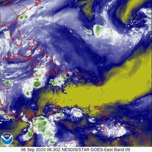
ONAMET monitors three areas of downpours and electrical storms, located over the central and eastern Atlantic and the Caribbean Sea with a probability of 30 and 80%, in addition to monitoring a low-pressure area in the southwest of the country in the Caribbean Sea with a 10 % probability of becoming a tropical cyclone in the next 48 hours.
For tomorrow, Monday, an anticyclonic circulation in various levels of the troposphere will limit the cloud development over our country, giving rise to a low rainfall environment in almost the entire national territory. However, during the afternoon the scattered downpours and thunderstorms will return, due to the instability left by the passage of the tropical wave over the regions: northeast, southeast, the border area, and the Central Mountain Range.
By Tuesday, the effects associated with a tropical wave located to the east of the Lesser Antilles will be positioned near our territory, causing instability and providing moisture so that scattered showers and thunderstorms occur from early in the morning, over the regions: east, northeast, southeast, the border zone, and the Central Mountain Range.