The country expects heavy rains due to passing of storm
Santo Domingo, DR
The probabilities of heavy rains, storm force winds, and abnormal swell due to the proximity of storm Fiona towards the Dominican territory, have already caused the activation of weather warnings in at least four provinces.
Samaná, La Romana, La Altagracia, and María Trinidad Sánchez are the first locations under warning, as announced last night by the Emergency Operations Center (COE) in its most recent bulletin.
This green alert issued for the four provinces is declared given the expectations of a phenomenon that allows forecasting the occurrence of an event of dangerous character for the population.
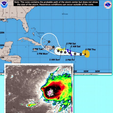
In the communiqué, the COE specified that storm Fiona presents maximum sustained winds estimated at 95 kilometers per hour (km/h) with higher gusts.
Meanwhile, its storm-force winds extend to 220 kilometers east of its center, and the minimum central pressure was estimated at 1002 millibars.
The National Meteorological Office (Onamet) announced an early weather alert for possible tropical storm conditions from La Romana to Cabo Engaño and Cabo Engaño to Cabrera.
This measure is still in effect because of its geographic location and trajectory; the tropical cyclone requires that civil protection institutions and the population give “strict monitoring.”
According to Onamet, the storm’s center was located near latitude 16.3 north and longitude 55.4 west, about 685 km from the Leeward Islands (Lesser Antilles).
They also pointed out that Fiona is moving westward at about 22 km/h and is expected to continue with this movement during the next few days.
According to the forecast trajectory, the center of this system will move over the northern Lesser Antilles this Friday night.
Fiona intensifies
On the other hand, according to the National Hurricane Center (NHC), the tropical storm Fiona intensified in its advance towards the Leeward Islands (Lesser Antilles), and watches have already been issued for Puerto Rico and the Virgin Islands.
The NHC forecasts that the center of this seventh named storm of the season will move through the Lesser Antilles this Friday night and early Saturday morning, then move near the Virgin Islands and Puerto Rico late Saturday night and early Sunday morning.
NHC also warned that Fiona would produce rain in the eastern Caribbean, with a risk of isolated flooding and mudslides in elevated areas, as well as storm surge and storm surge.
The seventh
Since the start of the cyclonic season, which begins on 1 June and ends on 30 November, seven named storms have formed in the Atlantic basin, of which two, Danielle and Earl, have reached hurricane status.
Onamet urged the population to be attentive to the bulletins it issues and the COE’s recommendations.
It suggests the population follow the guidelines and orientations of the civil protection organizations to keep in contact with the Civil Defense, Armed Forces, Red Cross, and the National Police and Fire Brigades.
They also recommended being attentive and taking the necessary precautionary measures in case of possible floods and flash floods during downpours, especially for residents in high-risk areas near rivers, streams, and creeks.
Alert
The contingency plan
Impact.
The Ministry of Public Health informed that it activated its Contingency Plan to reduce the impact that storm Fiona could cause in case it touches Dominican soil.