
Heavy rainfall expected to affect the territory starting this Tuesday

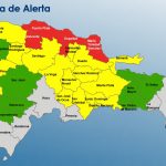
Santo Domingo.- The National Meteorological Office reported that isolated morning showers are expected this Tuesday in La Altagracia, San Pedro de Macorís, Hato Mayor, Greater Santo Domingo, and San Cristóbal.
In the afternoon, showers will extend to Monte Plata, El Seibo, Samaná, and Sánchez Ramírez. However, the most significant activity, with moderate to strong downpours, thunderstorms, and gusty winds, is anticipated in the northwest, north, and Central Mountain Range, particularly in Monseñor Nouel, La Vega, Santiago, Duarte, Hermanas Mirabal, Espaillat, and Santiago Rodríguez, among other nearby provinces. This weather pattern is due to a trough at various levels of the troposphere and increased humidity.
For Wednesday, the deep trough and low circulation southwest of the country will significantly impact the Dominican Republic from the early morning hours. A substantial increase in rainfall is forecast, with moderate to strong, and even torrential downpours locally, accompanied by thunderstorms and gusty winds. These conditions may lead to flooding and the overflowing of rivers, streams, and ravines, especially in Pedernales, Barahona, Azua, Peravia, San Cristóbal, San José de Ocoa, Greater Santo Domingo, and the National District. Other affected areas include municipalities in the provinces along the Caribbean coast and extending to the Central Mountain Range, north, and northeast throughout the day and night.


It was clearly obvious, by simply looking at windy.com, that Tuesday was going to be a decent day. It is today…Wednesday when the rain begins. Always trust a Dominican forecast…either a day early or a day late.