Melissa is reaching hurricane force: where it is and what effects it will continue to cause
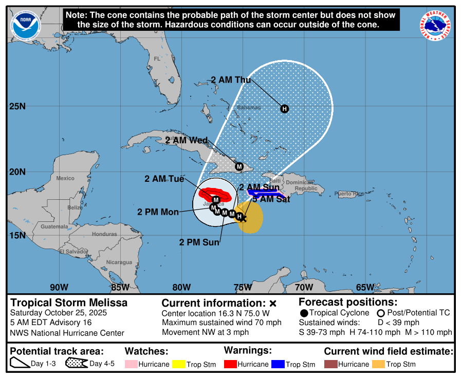
The Dominican Institute of Meteorology (Indomet) reported that at 7:00 am this Saturday, tropical storm Melissa was located near latitude 16.3 north and longitude 75.0 west, about 385 km southwest of Port-au-Prince (Haiti) and about 270 km southeast of Kingston (Jamaica).
Santo Domingo.- The institute added that the storm is moving northwest at about 6 km/h (4 mph). A slow westward/northwestward-to-westward motion is expected today and will continue through Sunday. A turn toward the north/northeast is forecast for Monday and Tuesday.
“Tropical Storm Melissa will continue to bring frequent, sometimes intense rainfall, mainly over the southeast, southwest, and northeast regions with isolated gusts of wind,” Indomet stated.
Indomet continued: “Tropical-storm-force winds extend approximately 185 kilometers outward from the center. The minimum central pressure is 986 millibars.”
The institute added that as Melissa moves northward, cloud cover will continue to reach us, bringing heavy rains, mainly to the Caribbean coastal provinces, where flood warnings remain in effect.
«The highest accumulated rainfall values (in mm) that occurred the day before yesterday are: Santo Domingo Este 177.9, Centro de los Héroes 175.6, Los Prados 160.5, Bella Vista 145.5, Cerros de Arroyo Hondo 144.8, Ensanche Paraíso 136.4, Peravia 103.1, La Victoria 106.3, Polo 107.5, San Cristóbal 125.0, Duarte 94.7, among others,» Indometspecified.
Additionally, the Government reported that the waves continue to be abnormal on the Caribbean coast, with waves exceeding 8 feet and breaking waves. Fragile, small, and medium-sized vessels should remain in port, while tourist resorts should take precautionary measures to protect facilities near coastal areas. Meanwhile, on the Atlantic coast, vessels are advised to navigate with caution near the coast without venturing out to sea.