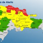
Scarce rains and high temperatures will be the dominant pattern for Dominican Republic in the next 24 to 48 hours

For today light cloud concentrations will be observed with light rains towards some towns in the northeast, southeast, southwest and the Central Cordillera as an effect of the transport of cloud fields caused by the east/southeast wind, however, these precipitations will not be significant, due to the incidence of anticyclonic circulation at almost all levels of the troposphere over the Dominican territory.
For Monday and Tuesday, the weather pattern will remain very similar to that of today, it will be characterized by scarce rainfall and high temperatures. The precipitations that may be presented will be isolated showers in the northeast and the Cordillera Central in the afternoon.
Temperatures will continue to be hot, especially in urban areas, due to the time of year and the warm east/southeast wind. ONAMET encourages people to drink enough liquid, to wear light clothes, preferably in light colors, and not to be exposed to solar radiation for prolonged periods between 11 in the morning and 4 in the afternoon.
ONAMET informs the entire population in general that it is necessary to adopt measures to guarantee the rational use of water, due to the rainfall deficit that has been affecting our territory for the last few months.
Today: Partly cloudy at times with light rains towards towns in the Northeast, Southeast, Southwest, and Central Cordillera regions.
Monday: Mostly sunny sky in much of the country due to the incidence of the high-pressure system.
Santo Domingo and its municipalities: Cloudy mornings with scattered showers.
National District: Scattered clouds, partly cloudy at times with passing showers.
Tuesday: Mostly sunny in much of the country with some occasional cloud increases.
Santo Domingo and its municipalities: Scattered clouds, partly cloudy at times.
National District: Partly cloudy at times.


