
Geologist Osiris de León calls for warning system for the Dominican coasts in the event of a possible tsunami

Geologist Osiris de León makes a call to raise awareness about natural phenomena. (DIARIO LIBRE/DANIA ACEVEDO) He reminded us that a tsunami in an area like Matanzas can reach waves of up to 15 meters, which can devastate the community, as it did in 1946.
Santo Domingo — Geologist Osiris de León considered that no country in the world is prepared for a major earthquake or a tsunami, lamenting that there are no signs on the Dominican coasts indicating safe places and how to save oneself in the event of such a phenomenon.
He gave the example of the August 4, 1946, tsunami in the community of Matanzas, María Trinidad Sánchez province, where there are even more houses today than at the time of that historic event.
“You can go to Matanzas, and there is nothing signposted, and that is worrying because a tsunami in that area can reach waves of up to 15 meters”, said the expert, warning that there must also be a day of awareness of the population through drills.
Why should it be signaled?
The expert stated that regarding tsunamis, there is much to be done in the country in terms of education, as people need to understand why this phenomenon occurs, how high it can reach in a coastal area, and whether their home or school is at risk.
He said, “If you go to Puerto Plata today and ask the people there what they would do in the event of an earthquake or tsunami, the residents would answer the same way: run away.”
“When a call for evacuation of a coastal zone arrives, we must first know which are the safe places, but here, we do not have marked coasts in the Dominican Republic,” he said.
He said that the first thing that has to be done is to mark the coast as a danger zone and a safe zone.
“It is good that people know, because if you run parallel to the coast you are not really protecting yourself, you have to run perpendicular to the coast and towards a high place and how do you do that, with a periodic drill and signage,” he added.
A tsunami on the Nagua and Cabrera roads, there would be no way out
He mentioned the area between the communities of Nagua and Cabrera, in the María Trinidad Sánchez province, as an urgent example of why it should be signaled.
“In some areas such as between Nagua and Cabrera the road goes right to the edge of the coast, but there is no high place where you can protect yourself either as a neighbor of the area or as a driver,” he said.
He said that on this road, parking lots should be built on a pedraplén at a height of at least 10 meters above sea level, with a sign indicating a safe zone in case of a tsunami.
“If any of us are surprised by a tsunami between Nagua and Cabrera or between Nagua and Sanchez, halfway, we have no way out; we have nowhere to go,” he said.
It is recalled that a tsunami is a series of waves originating from the ocean that send large waves of water, sometimes reaching heights of 30.5 meters inland.
What was the 1946 tsunami like?
According to a report published by the National Seismology Center, the largest earthquake in the instrumental seismic history of Hispaniola occurred on August 4, 1946. It was an earthquake of magnitude 8.1, which generated a tsunami as a result of the seismic shock.
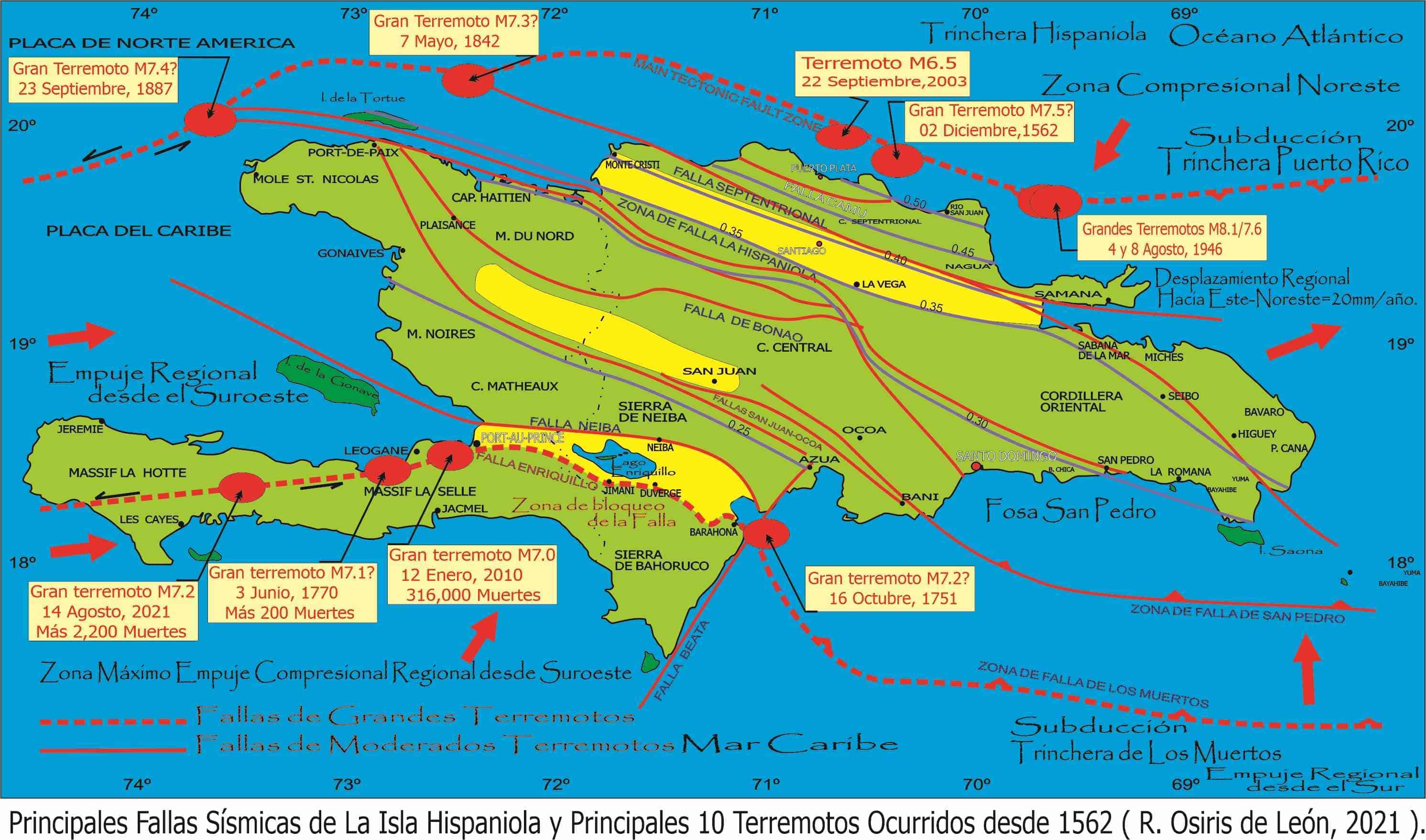
Map of the faults and places where the most significant earthquakes have occurred in the history of the country. (IMAGE COURTESY OF OSIRIS DE LEÓN, GEOLOGIST)
“The town of Matanzas was totally devastated by gigantic waves that reached more than 9 feet in height; penetrating up to 2 kilometers towards land, leaving only 8 of some 300 houses built of wood, the rest were torn to pieces. The towns of Cabrera, Nagua and Sanchez were left without communication due to the collapse of several bridges”, says the report.
Historical data collected by the National Seismology Center speak of some 1,000 fatalities.
Another effect of the earthquake was that the Municipal Palace in Moca collapsed.
Haiti’s earthquake should reconsider the Dominican Republic (DR) model.
Osiris de León, who referred to the subject while participating in the conference “Navigating in danger, tsunamis, earthquakes and hurricanes,” made a call to the country about the earthquake that occurred in Haiti in 2010, recalling that it was on the island.
“It was on the island, and that has forced us to assume a responsibility in terms of seismicity because we are registered internationally as the island that has had more deaths in this entire region and that we occupy the second place in global history,” he said.
He said that the January 12, 2010, earthquake prompted a review and change of the model, remembering that in that quake, majestic buildings built using all the processes of the past century fell.
He added that the reason why these great buildings fell is because they were built on clay and flexible soil.
No country prepared
The geologist noted that a significant indicator that no country is prepared for a major earthquake is the one that occurred in Turkey on February 6, 2023.
“Turkey thought it was prepared and had sold earthquake resistant apartments and those were the first to fall. That has been seen in California, Chile, Japan,” he said.
The most devastating earthquakes in Dominican history
The following is a history of some of the earthquakes that Dominicans remember for their effects and magnitude:
August 4, 1946
September 23, 1887
September 22, 2003
May 7, 1842


Yes.. this is something very important. There are many beach communities that would be wiped out by tsunami waves. Very good suggestion !