Storm Laura continues to pass through Dominican territory
SANTO DOMINGO.- Storm Laura continues its passage through the Dominican Republic, leaving strong winds and rains throughout the national territory.
The National Meteorology Office indicated that the tropical storm continues to move while interacting with the Dominican relief through the Central Mountain Range’s southern slope.
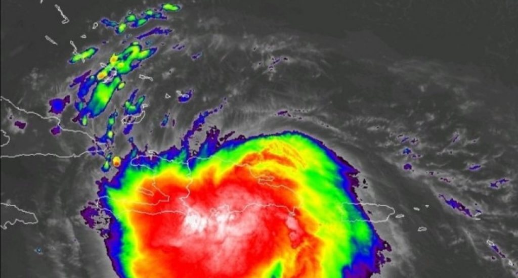
Onamet said that, despite this, Laura maintains a very compact cloudiness area with intense convective cells, which are producing heavy downpours accompanied by thunderstorms and windy conditions.
This, especially about La Altagracia, La Romana, San Pedro de Macorís, Greater Santo Domingo, San Cristóbal, San José de Ocoa, Peravia, Azua, Barahona, Independencia, Bahoruco, San Juan, La Vega, Monsignor Nouel and Pedernales. Occasional downpours are also observed in the rest of the country.
The National Meteorology Office (ONAMET) maintains the tropical storm warning from Cabo Engaño to Punta Palenque and from Cabo Engaño to the Bay of Manzanillo.
The office added that at seven in the morning this Sunday, the center of tropical storm Laura was located at latitude 18.9 north and longitude 71.5 west, near Las Matas de Farfán, near the border, and about 120 km to the southeast of Cap Haitien. Its center is expected to be outside the territory in the next few hours.
It is also moving west/northwest at about 30 km/h, with maximum sustained winds of 75 km/h—minimum central pressure of 1005 millibars.
The numerical models indicate accumulated rainfall values between 100 and 200 millimeters and can reach 250 mm in isolated points.
Due to this, the Onamet maintains the meteorological warning against flooding of rivers, streams and ravines, as well as sudden and/or gradual floods and landslides in the provinces: La Altagracia, Hato Mayor, El Seibo, San Pedro, La Romana, Monte Plata, Duarte (especially the low Yuna), Sánchez Ramírez, La Vega, Monsignor Nouel, San Cristóbal, Samaná, María Trinidad Sánchez, Hermanas Mirabal, Espaillat, Puerto Plata, Monte Cristi, Peravia, San José de Ocoa, Azua, Barahona , Bahoruco, Independencia, San Juan, Santiago and El Gran Santo Domingo.
Also, it raises Dajabón, Elías Piña, Santiago Rodríguez and Valverde from alert to meteorological warning for the same conditions.
Forecasters added that the swell would continue with heights between 6 to 8 feet, increased between 10 and 12 feet during this Sunday, throughout the country’s coastal perimeter; therefore, light vessels must remain in port throughout the coastal boundary, until conditions return to normal.