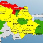
A trough arrives in the Dominican Republic today; there will be rains and thunderstorms

The rains and other conditions will be registered towards the northeast, southeast, the central mountain range and Greater Santo Domingo.
Greater Santo Domingo will be one of the affected demarcations
A trough will arrive this Monday in the Dominican territory, which will cause cloudiness with downpours, thunderstorms, and gusts of winds, according to reports from the National Meteorology Office (ONAMET).
The rains and other conditions will occur towards the northeast, southeast, the central mountain range, and Greater Santo Domingo.
The trough will be combining with the local effects of the possible remnants left by the tropical depression Josephine, which will extend its axis over the Dominican Republic.
Watching two tropical waves
Onamet said it monitors two tropical waves, the first located about 1,100 km east of the Lesser Antilles.
“Right now, it has a low probability of becoming a tropical cyclone by 20% in the next 48 hours. And the second one is near the coasts of Africa, it is generating downpours, and disorganized thunderstorms have low probabilities in the next 48 hours,” the agency said in its report posted on Onamet’s website.
The forecast added the population’s recommendation to avoid prolonged exposure to the sun from 11:00 a.m. to 4:00 p.m. In addition to drinking sufficient liquids and wearing lightweight clothes, preferably bright colors due to the high temperatures.
“The rainfall deficit continues to affect us for several months. Therefore, measures for the rational use of water must be adopted.”


