Hurricane Erin sits 290 km off Punta Cana, bringing downpours and 10-foot waves
Santo Domingo — This Sunday, cloud bands from Hurricane Erin are approaching Dominican territory, producing localized downpours, thunderstorms, strong wind gusts, and dangerous waves over provinces in the North Atlantic of the country, such as La Altagracia, La Romana, San Pedro de Macorís, El Seibo, Hato Mayor, Samaná, María Trinidad Sánchez, Duarte, Espaillat, Puerto Plata, and Montecristi.
The Dominican Institute of Meteorology (Indomet) reports that as this system moves west/northwest, it will extend especially toward Santo Domingo, Monte Plata, Santiago, La Vega, Monseñor Nouel, among other places.
Indomet maintains the meteorological advisory level due to the indirect effects of Hurricane Erin, given the risk of dangerous waves, swells, rip currents, waves over 10 feet high, and possible urban flooding, towards the provinces of La Altagracia, El Seibo, Hato Mayor, Samaná, María Trinidad Sánchez, Espaillat, Monte Plata, and Monte Cristi.
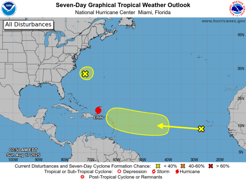
Location of the hurricane
The powerful Category 3 Hurricane ERIN on the Saffir-Simpson scale is located approximately 245 km north of San Juan, Puerto Rico, and about 290 km northeast of Punta Cana. It is moving west/northwest at a forward speed of 22 km/h (14 mph), with maximum sustained winds of 205 km/h (125 mph).
“We continue to constantly monitor the evolution and trajectory of this tropical system; it is important to stay tuned for updates,” says Indomet.
Other phenomena
A large area of disorganized showers and thunderstorms near North Carolina has a very low probability of cyclonic development at 10% over the next 48 hours and 7 days. Due to its position and distance, this system poses no threat to the Dominican Republic.
While an area of disorganized showers and thunderstorms associated with low pressure could form over the tropical Atlantic with westward movement.
Localized showers, isolated thunderstorms, gusty winds, and possible urban flooding are forecast for Greater Santo Domingo. The minimum temperature will be between 22°C and 24°C, and the maximum between 33°C and 35°C.
By Monday, Hurricane Erin will be moving away from our forecast area. However, we will remain under its indirect effects, bringing moderate to heavy downpours, thunderstorms, and frequent wind gusts to several towns across the country, especially in the southwest and southeast starting this morning. These precipitations will extend to towns in the provinces of the Central Mountain Range and the border area until the early evening. The indirect effects of Hurricane Erin, from Cabo Engaño (La Altagracia) to Monte Cristi, and on the Caribbean coast, from Saona Island (La Altagracia), advise operators of all types of vessels to remain in port due to wind, abnormal waves, and reduced visibility. The rest of the Caribbean coast can navigate with due caution.