
Atlantic alert: Tropical cyclone expected to form south-southeast of Bermuda
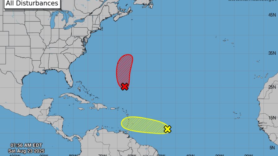
NHC graphic showing the imminent development of a low-pressure system in the southwest Atlantic and a tropical wave moving toward the Windward Islands. ( EXTERNAL SOURCE )
AL90 system near Bermuda
Recent satellite imagery confirms the formation of a low-pressure area approximately 500 miles south-southeast of Bermuda. This system, identified as AL90, continues to show signs of organization, with associated showers and thunderstorms intensifying.
The forecast calls for a tropical depression to form later today or tonight, with the potential to become a tropical storm on Sunday as it moves north.
A U.S. Air Force reconnaissance aircraft is scheduled to investigate the system this afternoon to gather more information. Bermuda residents and authorities are advised to closely monitor the development of this phenomenon, as additional warnings may be issued in the coming hours.
- Probability of formation in 48 hours: High (close to 100%)
- Formation probability in 7 days: High (close to 100%)
Tropical wave east of the Windward Islands (AL99)
On the other hand, a tropical wave designated AL99, located about 850 miles east of the Windward Islands, is generating disorganized showers and thunderstorms.
This system is expected to bring localized heavy rains and gusty winds to parts of the Windward Islands between Sunday and Monday. However, by mid-next week, conditions in the central Caribbean will become unfavorable for further cyclone development.
- Probability of formation in 48 hours: Low (10%)
- Formation probability in 7 days: Low (20%)
Recommendation
The NHC urges residents in potentially affected areas to stay informed through official sources and follow the recommendations of local weather services. For detailed marine conditions, consult the National Weather Service’s High Seas Outlook.


Why do we care about a tropical cyclone forming south southeast of Bermuda ??