Climate change: Storm Melissa and tremors: why the Dominican Republic faced strong phenomena in 2025
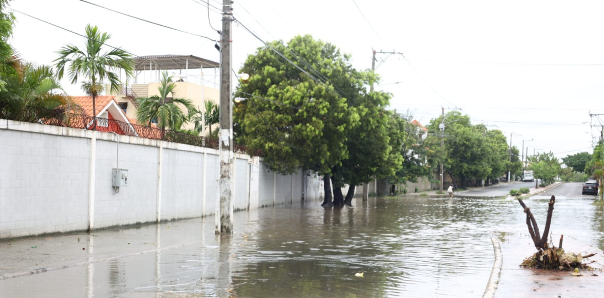
Streets of the Ensanche Isabelita flooded by rains from storm Melissa. Photo| Guillermo Burgos| HOY Newspaper
2025 has been an intense year. In good Dominican, “he has given a lot of water to drink.” Hurricane Erin, Storm Melissa, earthquakes that have shaken different parts of the country, and episodes of extreme weather have marked the national agenda.
And although the country did not register more events than expected, it did experience much stronger, wetter phenomena capable of causing impacts even without making landfall in the Dominican Republic.
The weight of the season: Melissa and Erín
Engineer and senior meteorologist Saddan Font-Frías Montero, in charge of the National Forecast Center of the Dominican Institute of Meteorology (INDOMET), explained to Hoy that in 2025 the Dominican Republic registered two relevant atmospheric events associated with tropical cyclones: hurricanes Melissa and Erín.

The engineer and senior meteorologist, Saddan Font-Frías Montero.
Neither directly impacted the country, but both generated dangerous waves, extensive cloud bands, and significant rainfall, most notably Melissa, which became the most influential system of the year.
Melissa, the storm that left its mark
Although it passed far from our shores, Melissa later became a powerful hurricane that hit Jamaica and Cuba, leaving millions in losses. For the Dominican Republic, it was a “remote” event, but with effects from a nearby system.
Montero explains that Melissa was an exceptionally intense and energetic cyclone, which:
- It reached category 5,
- It presented a process of rapid intensification (explosive cyclogenesis),
- And it sustained powerful winds for a long time.
Its outer bands, wide and persistent, left extraordinary rains in the country:
- Polo, Barahona: 737 mm
- Heroes Center (DN): 507 mm
- Santo Domingo East: 453 mm
“This combination of intensity, duration and wide circulation made it the system that contributed the most to the increase in ACE in the 2025 season,” the expert detailed.
Why Melissa Got So Strong

Map of Melissa’s rains. Photo
According to Montero, the tropical Atlantic presented significant warm anomalies during the 2025 season, with temperatures above the historical average.
That warmer ocean enabled rapid intensification, longer-lasting intense hurricanes, and greater moisture.

Ocean temperature anomalies in 2025. Photo
“These conditions are consistent with the patterns seen in a warmer climate,” he said.
The most affected areas in the DR
Although Melissa did not make landfall, its outer bands interacted with the Dominican orography and generated extreme rainfall in:
- Southwest (Polo, Barahona): urban and rural floods.
- Greater Santo Domingo: flooding of ravines, fallen trees, and floods.
- San Cristóbal: intense floods and accumulations.
“The data confirms a trend towards more intense rains associated with more energetic cyclones, even when they do not directly impact the country,” Montero said.
What was observed in 2025
- Stronger cyclones, although not necessarily more numerous.
- More frequent rapid intensification.
- Greater volume of rain in less time, especially in urban and mountainous areas.

Rainfall in October: Data
A behavior that coincides with international studies on wetter and more intense hurricanes on a warmer planet.
Were there more events in 2025?
No, but they were more intense.
Montero explains:
Among the causes:
- Warmer than average sea temperatures.
- The transition from the El Niño to the Neutral phase to La Niña reduces wind shear.
- An atmosphere with a higher moisture content.

Status of the phenomenon of La Niña
The strongest tremors of 2025
While the country dealt with rain and waves, the land was also active. Seismic activity was higher than in 2024.

Ramón Delanoy, director of the National Seismology Office of the UASD.
The director of the National Seismology Office of the UASD, Ramón Delanoy, explained that in 2025, 3,971 earthquakes were registered, compared to 3,652 the previous year.
Distribution
- 48 earthquakes greater than 4.0
- 82 between 3.5 and 4.0
- 668 between 3.0 and 3.5
- 2,701 between 2.0 and 3.0
- 472 under 2.0
Three faults stood out: Ocoa, Septentriona, and Canal de la Mona. Among the most essential earthquakes:
- January, magnitude 5.5, located 6.5 km ESE of Las Terrenas, Samaná
- Depth: 118 km
- Latitude 19.288 / Longitude -69.486

Earthquakes registered in 2025, the most important are in red—photo
In total, 11 earthquakes were the strongest of the year and were felt in Miches, Isla Catalina, Monte Plata, Sabana Larga, Villa Isabela, Puerto Plata, Las Terrenas, among others.
What’s coming in December
While the country focuses on Christmas Eve, Santa Claus, and light bulbs, the atmosphere sets a different pace. December officially opens the front season.
Meteorologist Cristopher Florian explained to Hoy that during this month, cold front systems begin to enter.

Meteorologist Cristopher Florian. Photo
Christopher Florian:
What do they cause?
A cold front displaces warm air, generating significant cloudiness, frequent rainfall, and a cool environment typical of the North Atlantic.
Among the provinces that will feel it the most are: Puerto Plata, Espaillat, Hermanas Mirabal, María Trinidad Sánchez, Samaná, as well as Hato Mayor, El Seibo, and La Altagracia.
In addition, these systems bring lower, more pleasant temperatures, as already experienced after the close of the hurricane season.
“At the beginning of the frontal season, these temperatures are capable of dropping to 5 °C, and even reaching –0.3 °C,” said Florian.
The traditionally coldest areas of the country – Valle Nuevo, Constanza, and Alto Bandera – will be the protagonists of the thermal drop.