Front system will continue to generate rainfall
The almost-stationary frontal system will continue to affect weather conditions over our territory today, with clouds expected from the early hours of the day, accompanied by downpours, thunderstorms, and isolated gusts of wind, towards the Atlantic coastal coast in the morning, reported the Dominican Institute of Meteorology.
In the afternoon, Indomet said that these rains would be observed towards the southeast, Central Cordillera, and the border area in provinces such as El Gran Santo Domingo, La Romana, El Seibo, San Pedro de Macorís, Hato Mayor, Monte Plata, Monseñor Nouel, La Vega, Santiago Rodríguez, Elías Piña, and Dajabón. It will be in Monte Cristi, Puerto Plata, Espaillat, and María Trinidad Sánchez at night.
Temperatures will decrease slightly at night and early morning due to a cool and moderate wind from the northeast.
In addition, the institute said that on Monday, from the early hours of the morning, some downpours and thunderstorms will occur again in provinces of the north coast, from La Altagracia to Puerto Plata, produced by the frontal system that will be located northeast of our territory. For the afternoon, downpours are forecast, being moderate to strong locally, with thunderstorms and gusts of wind towards the northeast, southeast, Cordillera, and the border area, concentrated mainly over La Altagracia, La Romana, El Seibo, San Pedro de Macorís, Hato Mayor, Monte Plata, Sánchez Ramírez, Samaná, Monseñor Nouel, La Vega, Santiago Rodríguez, Elías Piña and El Gran Santo Domingo.
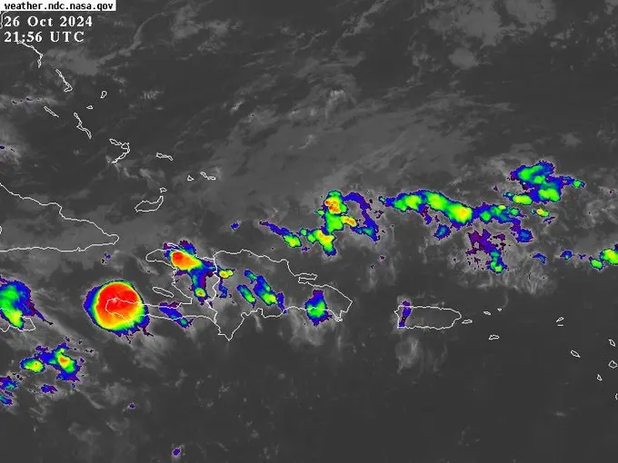
INDOMET reports that a wide area of low pressure is likely to develop over the southwestern Caribbean Sea in the middle of next week, with a 30% probability of cyclonic development in the next 7 days.