ONAMET monitors three areas of downpours associated with tropical waves

The incidence of Sahara dust limits rainfall
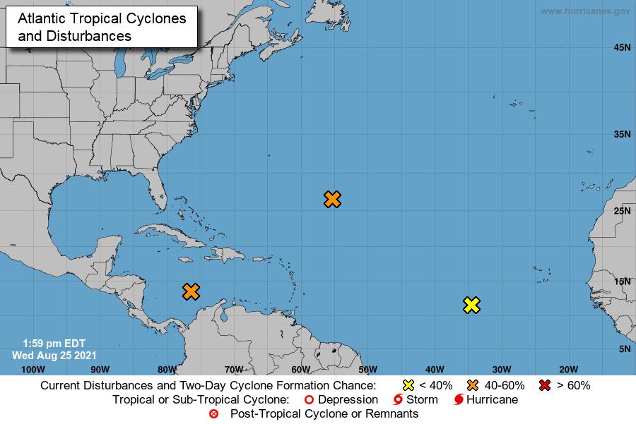
The National Bureau of Meteorology (ONAMET) monitors three areas of downpours and thunderstorms associated with tropical waves.
The first increased to a 30% chance of becoming a tropical cyclone and is located southwest of the country, in the waters of the Caribbean Sea.
The second also with a 30% chance of becoming a tropical cyclone in the next 48 hours and is located in the center of the Atlantic Ocean about 1,600 kilometers northeast of the Lesser Antilles, and the third maintains a 20% chance of becoming a tropical cyclone and is located hundreds of kilometers southwest of the island of Cabo.
For this Wednesday, the sky will be mostly cloudy due to the cloudiness provided by the tropical wave; however, its most significant activity is in the waters of the Caribbean Sea, so only a few showers are expected to the southwest.
While, for the afternoon, a sky with less cloudiness and grayish appearance will predominate due to the Particles of Saharan dust. Also, it is expected to occur some local showers with possible thunderstorms on localities of the southeast, northeast, and the Central Mountain Range, by the drag of the wind and the incidence of the trough in the high levels.
Local forecasts
In Greater Santo Domingo, the sky will look grayish due to the Saharan dust. The maximum temperature is between 32ºC and 34ºC (90°F-93°F); the minimum is between 22ºC and 24ºC (72°F-25°F).


